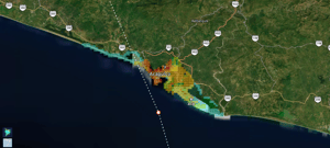
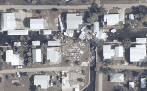
After quickly accelerating to a Category 5 system, Hurricane Otis made landfall approximately 8km (5 miles) south of Acapulco early morning on 25th of October 2023. Otis is the strongest hurricane to ever make landfall on the Pacific side of Mexico and is the first Eastern Pacific hurricane of this intensity. The storm's strong winds and torrential rainfall majorly impacted the coastal city of Acapulco.
MIS data partners were deployed immediately following the storm to acquire satellite imagery of the impacted areas with properties insured by our clients.
Collected imagery and data obtained from various sources has been aggregated and analysed by the MIS Intelligence team to determine where damage occurred, with specification of the severity and causation of damage.